1 Comment

AeroTestra UAS supports University of Hawaii at Hilo in FAA approved UAV flights


AeroTestra UAS supports University of Hawaii at Hilo in FAA approved UAV flights at National Park

  •  

On July 18 2016 University of Hawaii at Hilo's SDAV Lab, under a COA from the FAA, operated multiple UAV flights overPuuhonua O Honaunau National Historic Park. A first since the ban was established in June of 2014.

The project was spearheaded by Adam Johnson, Chief of integrated resources management for the park. Working for over a year to gain approval for the sensitive operations, he dealt with with, not only the restrictions of UAS operations in national parks, but also the sensitive historic archaeological site the park protects. 

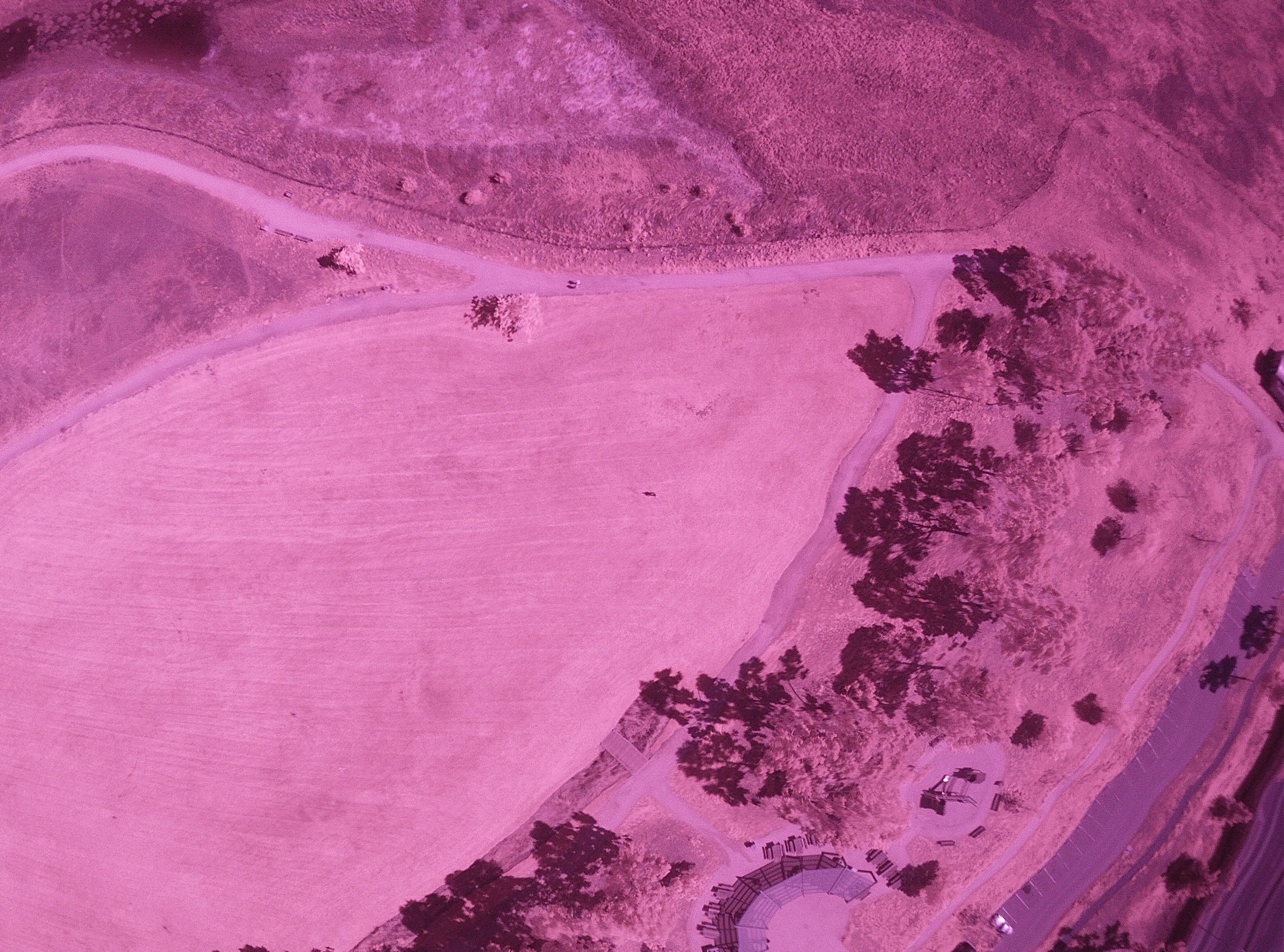
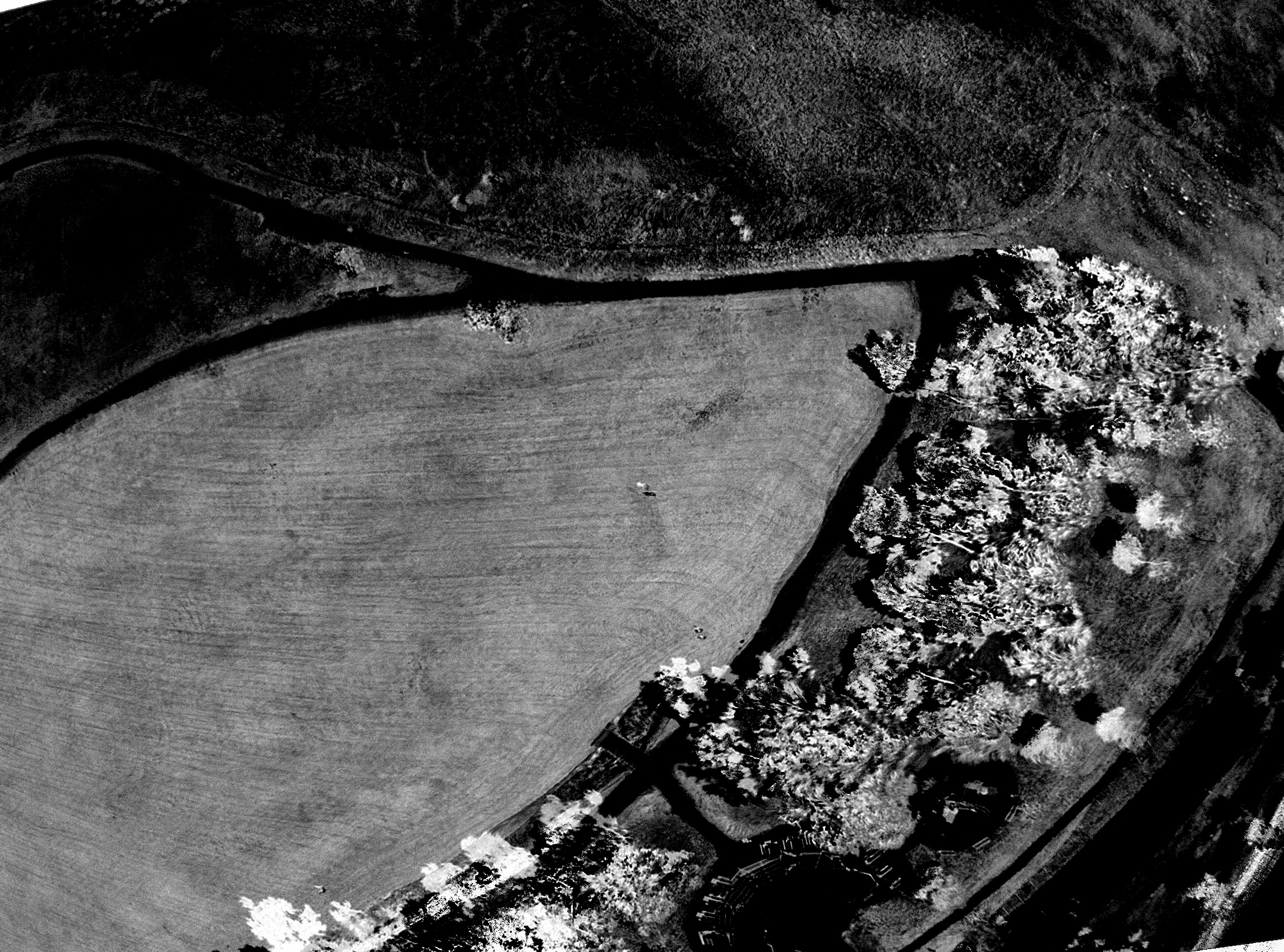
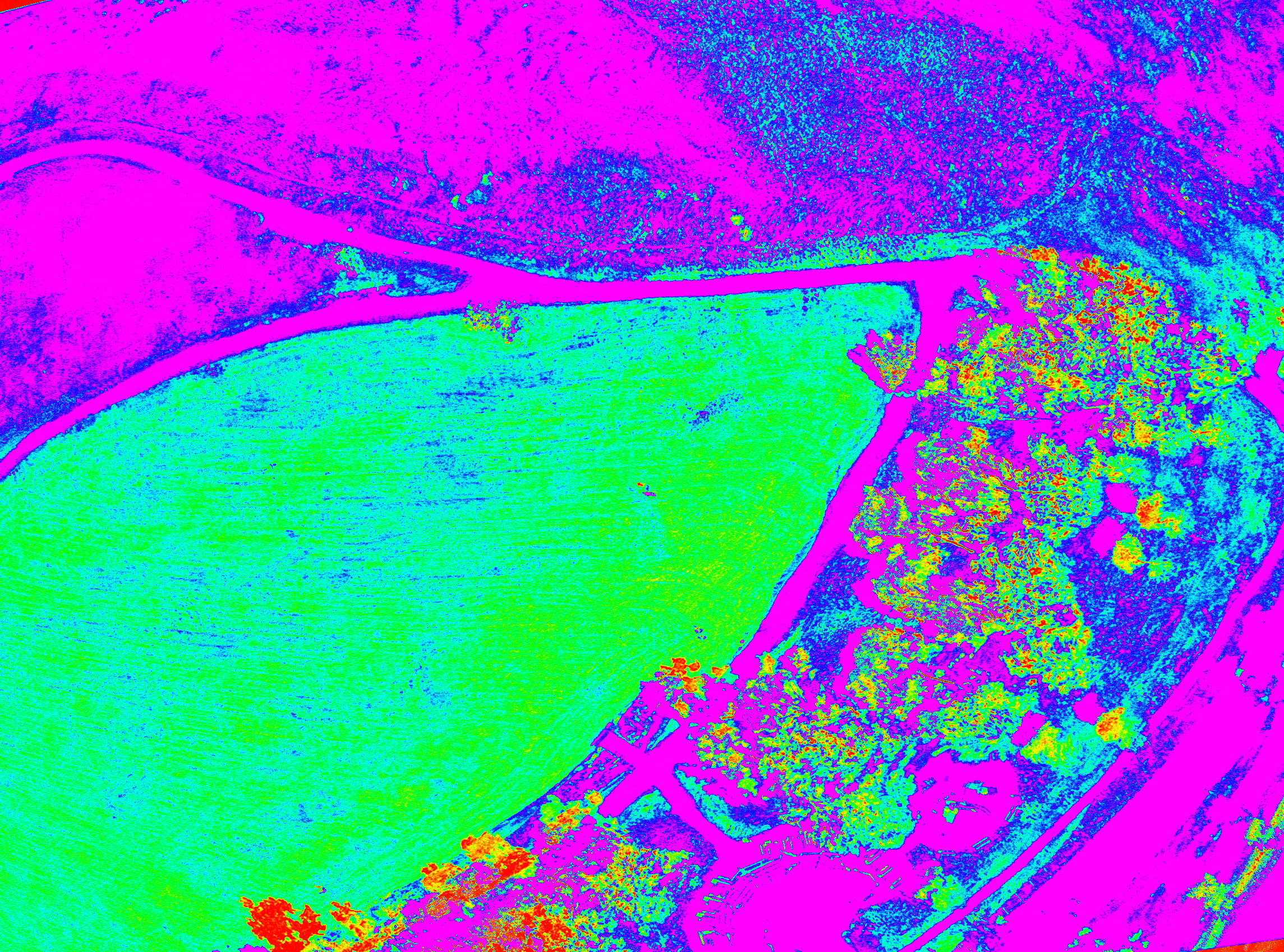
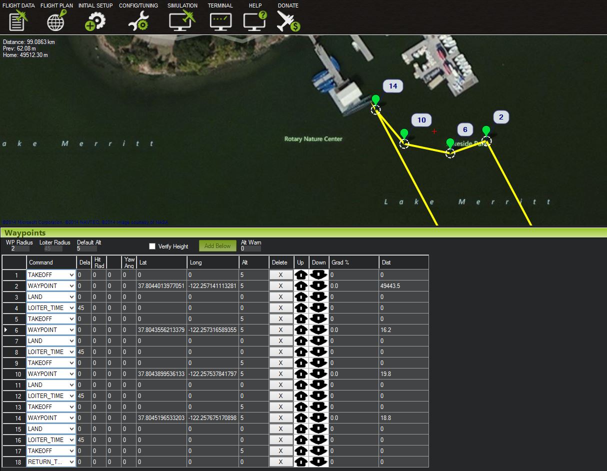
Partnering with University's Spatial Data and Visualization Lab the goal was to create a baseline measurement  of the healthy coconut trees in the park and attempt to identify the cause and scope of an illness that is affecting them. Two AeroTestra multirotor platforms were equipped, one with a high resolution visual range camera and the other a Headwall Nano hyper-spec sensor . Capable of measuring discreet variations in the vegetation's reflectance signatures, hyper-spectral data has long been used by satellites and manned aircraft systems for ground classification and agricultural monitoring .  


Ryan Perroy, Assistant Professor at the university and chief investigator on this project, is a strong supporter of unmanned  systems as a valuable research tool providing the ability to collect high quality data while having a minimal disruptive impact. Projects the lab has worked on range from lava flow monitoring to invasive species detection. 

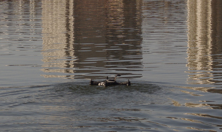
The flights were carried out by Nathan Stephenson , pilot in command, and research assistant at the university labs, supervising Sean Headrick of AeroTestra, in charge of operating the unmanned vehicles. 

By all accounts the missions were a complete success due to the diligent effort of everyone involved. This should provide a good example of the value UAS can provide as the industry opens to commercial use in the coming months.


I was confident and at ease the whole time knowing the expertise overseeing the flights and operations and level of care and attention that went into the planning and execution. Thank you for that providing that peace of mind.

Tammy Duchesne
Superintendent, Pu'uhonua o Honaunau & Kaloko-Honokohau National Historical Parks

1 Comment

AeroTestra MK10 Ducted Multi Rotor Aircraft

Over the past couple weeks we have begun flight testing on our newest aerial sensor platform. It is a standard quad rotor configuration with one major improvement. 

Below is a short video of our first test flight.

By fabricating a carbon fiber duct to surround the prop you can realize several benefits. Most obvious is the safety factor offered by enclosing the propellers. with a carbon fiber duct, a substantial impact could be survived without serious damage being suffered by the aircraft or persons or property.. 

There is also the increased efficiency due to the reduction of propeller blade tip losses. The ducted fan is more efficient in producing thrust than a conventional propeller, especially at low speed and high static thrust level . This "high static thrust" describes the way that a multi rotor operates. This can only be realized by getting very tight tolerance between the propeller tips and the body of the duct. 

Clearance between the propeller tip and duct body are > 1 mm. This reduces the induced drag and associated noise level creating a quieter more efficient propulsion system.

Clearance between the propeller tip and duct body are > 1 mm. This reduces the induced drag and associated noise level creating a quieter more efficient propulsion system.

Reducing the induced drag on the propeller tip has an added benefit of also reducing the associated noise. By shielding the noise and reducing the propeller tip drag the resulting noise level of the aircraft can be lowered substantially. 

Our first tests actually were a bit louder than a similar sized prop/motor combo used on the current MK09 (IVAN). This is likely due to a couple of factors including the result of an even number of props causing resonate vibrations in the duct as well as the inherent quality of a material like carbon fiber to act more as a speaker than to diffuse vibration(sound). Our upcoming iterations on this design will incorporate 3 or 5 blade configurations to counter this effect.


1 Comment

Near Infrared imaging Sensor in Development

Camera Selection

With a large amount of interest in the sUAS community focused on the uses in the agriculture industry, we have begun development on a lightweight, imaging set for acquiring NIR and RGB (visible spectrum) data sets. the "Horizon 1080 p HD camera" from Foxtech seems to be a good candidate. Our goal will be to modify one camera by removing the low pass or infrared blocking filter from behind the lens set and replacing with an "ultrablue" filter. The other camera we will leave as is. This camera system has been designed specifically for use with small remotely piloted aircraft and will produce images similar in quality to the GoPro camera. This design also features the ability of triggering the shutter via an extra channel on the remote or directly from the APM's (autopilot) trigger output. This will allow us to remove the servo from the system thereby decreasing the overall weight and increasing reliability through simplifying the electrical-mechanical interface. 

After removing the infrared blocking filter from the back of the lens a small peice of #74 "Ultra-blue" filter was cut to fit into the back of the lens holder. This filter has been developed by Public Labs to work best with CMOS sensors when capturing NIR images for vegetation analysis 

CMOS image sensor capable of seeing in the near infrared range once the filter is removed

CMOS image sensor capable of seeing in the near infrared range once the filter is removed

The camera lens disassembled to remove infrared blocking filter

The camera lens disassembled to remove infrared blocking filter

The #74 ultra-blue filter replaces the infrared blocking filter in the back of the lens holder.

The #74 ultra-blue filter replaces the infrared blocking filter in the back of the lens holder.

Below is a series of four images showing a standard RGB photograph, followed by a NIR (near infrared image) composite into a grey scale NDVI (normalized difference vegetation index). This shows the reflected infrared light that a healthy plant will reflect during photosynthesis. The final image is known as a false heat map and is designed to enhance a grey scale NDVI to show more clearly areas where the plant health is compromised due to pests, disease, lack of water or proper fertilizer.

1 Comment

Water Sensor Testing with Multirotor "drones"

Over this past weekend we were able to join Nerds for Nature at the Bioblitz at Lake Merritt in Oakland CA. While there we ran the first of a series of experiments using HUGO to land at predefined way points in the lake to receive and log sensor data from an array attached to the outside of the aircraft. For the proof of concept flights this weekend we recorded temperature and pH readings that were stored on a sD card located inside the shell. Check out our article in Scientific American

Sensor array mounted to the front of a specially outfitted HUGO capable of water landings.

Sensor array mounted to the front of a specially outfitted HUGO capable of water landings.

Here you can see the sensor array we have designed for water quality testing. At the front of the array is a temperature probe and behind that will be housed different sensors including pH, salinity, and dissolved oxygen.  Moving forward we hope to be able to develop and refine the data we are collecting as well as begin to create accurate maps and ongoing "monitoring stations" based on GPS coordinates.

Screen shot of Mission Plan

Screen shot of Mission Plan

Here you can see the mission plan created to indicate the sampling locations. Using this method it is possible to have virtual monitoring stations accurate to within a couple meters each time sample readings are taken. These would probably be at inlets and outlets of a body of water and possibly at  the location of on shore sources of pollution/runoff.

HUGO navigating to a GPS way-point or "monitoring station"

HUGO navigating to a GPS way-point or "monitoring station"

Landing to receive sensor readings.

Landing to receive sensor readings.

The first tests were quite successful with the flight plan executing as expected and all sensor data being recorded as planned. One note visible on the readings in the graph below indicate the temperature probe had yet to normalize before moving to the next location. We will make adjustments to the "delay" used to solve for this.

Graph of Temp, pH/time 

Graph of Temp, pH/time 

Proud Sponsor of University of Florida in AUVSI's RoboBoat 2014

The  RoboBoat Competition consists of student teams racing their autonomous surface vehicles (ASVs) through an aquatic obstacle course. This includes littoral area navigation, channel following, and autonomous docking. The competition provides an opportunity for students to develop skills in system engineering by accomplishing realistic missions with autonomous vehicles in the maritime environment.  

roboboat_REV copy_thumb.png

We are proud to be able to sponsor the Machine Intelligence Lab at University of Florida in the AUVSI 2014 RoboBoat Competition.  We are excited to  see how the robotics team does and wishes them the best in their efforts. 

UnivFla robotics team.jpg